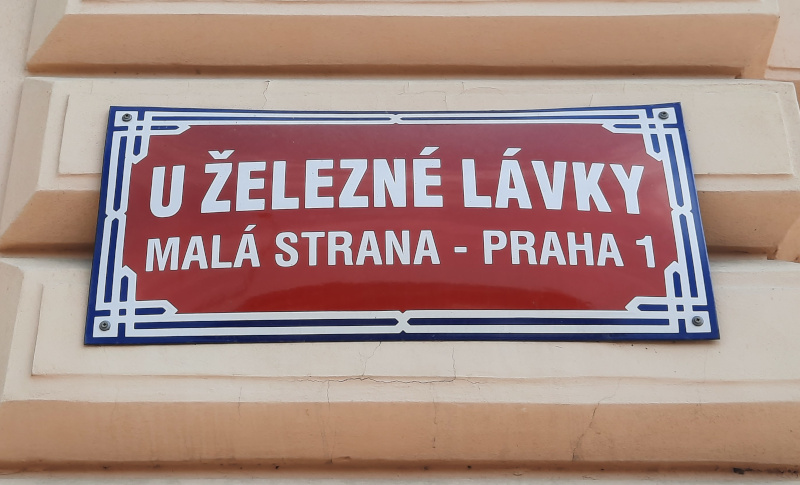
U Železné Lávky – At the Place of the Iron Footbridge
On the Prague Fords post I explained how present-day Prague developed and grew based on the ability to be able to cross here between both sides of the river for much of the year using a number of fords. Later there would be a ferry service and these were eventually replaced by footbridges which themselves were replaced by vehicular bridges. This is a brief story about the grandest of the footbridges, Železna Lávka or the Iron Footbridge which linked the present day area of Klarov on the Lesser Town side with Jan Palach Square on the Old Town side. So the road that led to the bridge from the Lesser Town side was, and still is, called U Železné Lávky.
The Crossing Changes
There had been a crossing place here that was first referenced in 1293 which connected the shoreline of the Old Town with the settlement called Pisek in today’s Lesser Town. Back then what we know as the Kaprova Ford was allowing both pedestrian and vehicular traffic across the river but if you did not want to get your feet wet there was a boat ferry here as well. Maps before 1869 refer to our street U Železné Lávky as Dolní Přívozní or “the Lower Ferry” (yes! there was an Upper Ferry as well which was close to the current National Theatre).
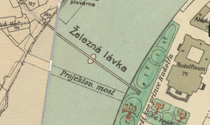
The map from 1909 above shows the position of our existing iron footbridge with the projected vehicular bridge (what is now called Manes Bridge). The lower ferry service ended in 1869 with the completion of two bridges in the area. The large vehicular bridge named after Emperor Franz Josef I and our smaller pedestrian iron footbridge named after the Emperor’s son Rudolph. Officially named Crown Prince Rudolph Bridge it connected with the Old Town side on the Crown Prince Rudolph Promenade and a square (todays Jan Palach Square). On maps you’ll find it referred to as either the Iron Footbridge (Czech maps) or Kettensteg (German maps that referred to it by it’s chain-link support design).
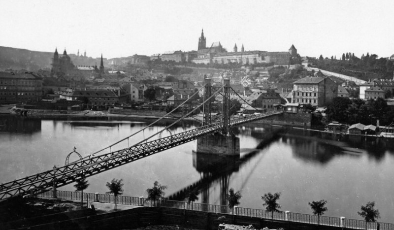
The picture above shows the finished iron bridge. Interesting to me is that the Prague Castle (centre-top) ST Vitus west entry towers have not yet been built so that dates it after 1868 but before 1880.
Imperial Prague
You have to understand the reason for the footbridge here. From a practical point of view it was thought that there would be no need for a road bridge in this location because of the new Emperor Franz Josef I bridge (todays Čechův Most) opening about 400 metres away. Secondly, downriver the only way that pedestrians could cross was either on the new big bridge (think lots of dust, workers, horse dung on the road etc) or one of the rickety wooden bridges that were frequently damaged by boats on the river. So it was envisaged that the Iron Footbridge at 3.8m wide, 192m long and 17m tall (5m above the water) would meet the needs of the upper classes as it was a toll bridge that would eliminate the riff-raff and would mean that society people could take a safe and reasonably healthy walk back and forth over the river.
The iron footbridge was removed in 1914 following the construction of the adjacent road bridge. But the street retains it’s old name U Železné Lávky.
The Odd House
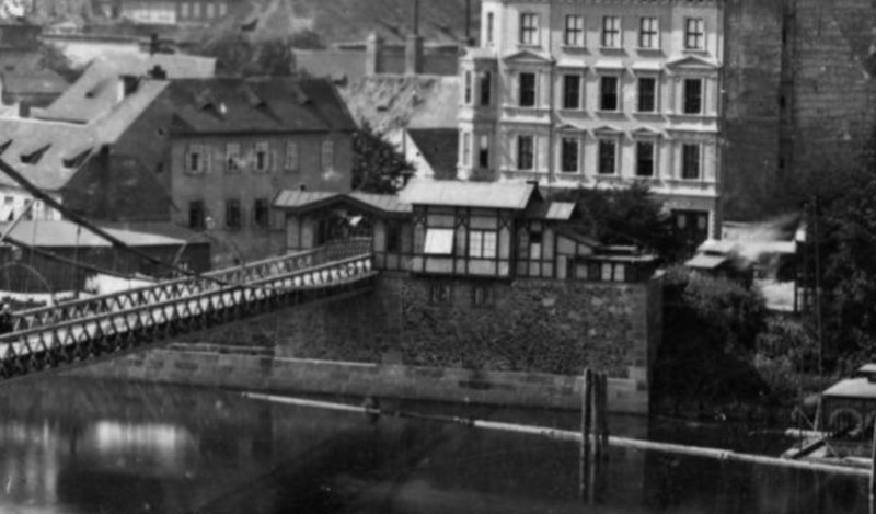
The picture above is cropped from the previous picture. It shows a timber-framed building on the Lesser Town side of the river which acted as the tollbooth for the Iron Footbridge.
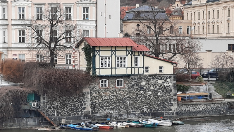
The picture above shows the same building but it’s the view that you now have when you cross the Manes Bridge heading from the Old Town towards the Lesser Town. You can see to the left of the building where the iron footbridge was supported as it meets the riverbank (above the blue boat).
One odd thing about the row of buildings that make up U Železné Lávky is that it begins with the number 4. You count down from the far corner building number 16, then 14, 12, 10, 8, 6, 4 and then nothing. So what happened to number 2? Actually it’s still there but to find it you have to walk to the riverside where you’ll find the half-timber framed building pictured above. That is number 2 i.e. the old tollbooth.
Weird Trivia
English? Although the bulk of the bridge was made of iron, all the chain supports and bridge bearings were made from steel produced in Sheffield.
Something Related or a Few Minutes Away
History/WW2 – Winged Lion Memorial
Attraction – The Old Castle Steps
Attraction – Museum of Decorative Arts
Art/Culture – The House of the Suicide Mother
Food/Drink – ST Wenceslas Vineyard
Food/Drink – Traffic Light Alley restaurant
My Own Guided Tours – Cheaper Than You Think!