Prague Jewish Garden
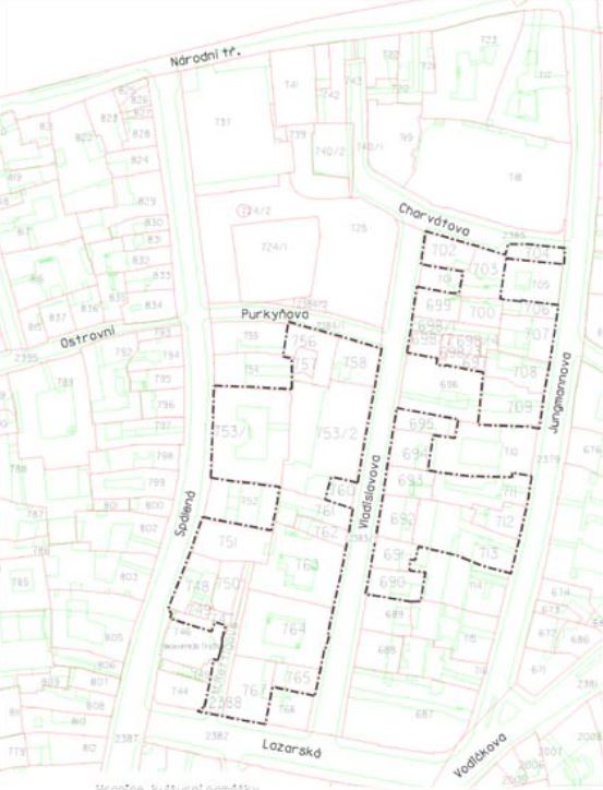
Not so fast, this is not some horticultural post about what grows in a Jewish garden. This relates to a cemetery close to Wenceslas Square that pre-dates the current Old Jewish Cemetery by 200 years and is recognised as the oldest Jewish burial ground in the country. In the mid-13th Century a Jewish cemetery occupied the area roughly enclosed by the current streets called Spálená, Jungmannová, Charvatova and Lazarská in the New Town and it was simply referred to as the Jewish Garden.
How This Begins for Me
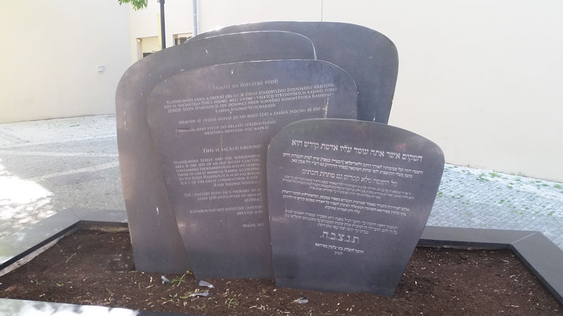
If you have stayed at the old Hotel Christie or what, at the time of writing is the Michelangelo Grand Hotel then you might have noticed a memorial next to the hotel garage formed like black marble gravestones pictured above leaning on each other like you see in the Old Jewish Cemetery and reading the text tells you that it marks the area of an old cemetery. The first thing you might assume is that this was one big cemetery. No, it seems to have been an enclosed area which was split into different parts, maybe to suit the needs of the different Jewish faiths.
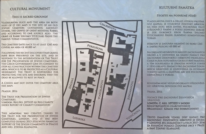
I was intrigued to see that the plaque said “A Cohen may not enter the cemetery area” so VERY IMPORTANT: If you are Cohen then you probably don’t want to stay at the Michelangelo Grand because in 2017 on one of my Walking Tours I personally experienced a Cohen of the Jewish Orthodox faith make a detour to avoid even walking under the trees growing in the Old Jewish Cemetery. That was the first time I learned that the Cohens were the priests and were forbidden to walk in the areas containing graves.
So there I had a memorial and a rough map of the area. I kind of put this deep in my memory, so deep that I forgot about it until the Covid-19 lockdowns when suddenly I had a lot of time on my hands.
Old Maps
It’s not for everyone but one of my interests is looking at old maps of Prague to see how it has changed over the years and there are several great online resources to do this.
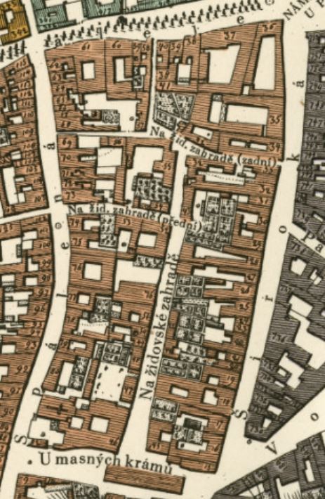
I was randomly browsing through a street map from 1816 (as you do!) when I came across a street that I know as Vladislavova but on this map it was called Na Zidovske Zahrade which means the On the Jewish Garden. Even though the plaque on the memorial makes no reference to the Jewish Garden it took about a second to make the connection. The map was useful because the roads at the top have additional bracket info i.e. “přední” means “at the front” and “zadní” means at the rear which indicated two original entries. Now to find out more.
Closed for Business
As the Jewish Ghetto area was defined in 1437 and all Jewish people had to move there and be buried there I’m pretty confident that 1437 would have been the last time the Prague Jewish Garden was used. This is backed up by the king of the period selling the land for development in 1478. But then a question. If this ceased being a functional cemetery in 1478 and was built over, why was the name still being used in 1816? The answer seems to be why not? There was no urgent need to change the name and in fact it was still known as the Prague Jewish Garden up until the 1860s. Then something happens called the Czech National Revival and all the streets in this area were renamed after famous Czechs fighting for recognition of Czech culture and language.
The Jewish Garden is Rediscovered and Protected
In post-Communist Czech a series of archeological digs between 1997 and 2000 discovered more than 400 bodies under buildings which had historically been built with no basement and so the ground had been undisturbed for more than 500 years. The boundaries of the Jewish Garden were finally agreed in 2013 and hence the money raised for preservation activities and the memorial were in place by 2016.
The Jewish Garden covers an area of around 48,000 square metres. In the current streets called Spálená, Jungmannová, Charvatova and Lazarská there are more than 40 plots of land which had previously been part of the cemetery and currently 18 buildings have a special protection order on them because they contain archeological sites relating to the Prague Jewish Garden.
Where Is The Jewish Garden?
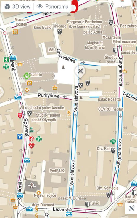
The easiest description is to go to the Quadrio Shopping Centre, walk out the rear door (by Kafkas Head) and turn right. You’ll see the memorial to one side on the left as you walk into Vladislavova and if you reach the front of the hotel you’ve walked 20m too far. The memorial is on the route of my Prague City Walking Tour.
Something Related or a Few Minutes Away
Jewish Prague – The Žižkov Old Jewish Cemetery
The Destruction of the Jewish Ghetto
The Rebuilding of the Jewish Quarter
Art and Culture – Modern Art of David Cerny (Kafka’s Head)
Parks and Gardens – Charles Square
Services – Quadrio Shopping Centre
My Own Guided Tours – Cheaper Than You Think!